

You can find on this page the Taiwan geographical map to print and to download in PDF. The Taiwan geographic map presents the topography, elevation, rivers, mountains, climate and physical features of Taiwan in Eastern Asia.

The Taiwan physical map shows landform and geography of Taiwan. This geographical map of Taiwan will allow you to discover physical features of Taiwan in Eastern Asia. The Taiwan physical map is downloadable in PDF, printable and free.
The main island of the archipelago is Taiwan Island, which comprises about 99% of the current jurisdiction of the Republic of China; the other 1% consists of the smaller islands of the archipelago such as Orchid Island and the Penghu islands, along with the tiny islets - Green Island and Hsiao Liuchiu as you can see in Taiwan physical map. The archipelago is separated from China by the Taiwan Strait, which ranges from 220 km (137 mi) at its widest point to 130 km (81 mi) at its narrowest point.
The islands of Quemoy, Matsu, Wuchiu, etc. across the Taiwan Strait, and Pratas and Taiping in the South China Sea, are also administered by Taiwan. These islands are however not part of the Taiwanese archipelago. Taiwan area is 35,980 km2 (13,892 sq mi) of which 32,260 km2 (12,456 sq mi) is land and 3,720 km2 (1,436 sq mi) is territorial water claims, making it slightly smaller than the combined area of Maryland and Delaware, or slightly bigger than territory of Belgium. It is 394 km (245 mi) long and 144 km (89 mi) wide as its shown in Taiwan physical map. It has a coastline of 1,566.3 km (973.3 mi). The ROC claims an exclusive economic zone of 200 nmi (370.4 km; 230.2 mi) and a territorial sea of 12 nmi (22.2 km; 13.8 mi).
The island of Taiwan was formed approximately 4 to 5 million years ago at a complex convergent boundary between the Philippine Sea Plate and the Eurasian Plate as its mentioned in Taiwan physical map. In a boundary running the length of the island and continuing southwards in the Luzon Volcanic Arc (including Green Island and Orchid Island), the Eurasian Plate is sliding under the Philippine Sea Plate. The western part of the island, and much of the central range, consists of sedimentary deposits scraped from the descending edge of the Eurasian Plate. In the northeast of the island, and continuing eastwards in the Ryukyu Volcanic Arc, the Philippine Sea Plate slides under the Eurasian Plate.

Taiwan topographic map shows the physical features of Taiwan. This topographical map of Taiwan will allow you to discover landforms and geographical of Taiwan in Eastern Asia. The Taiwan topographic map is downloadable in PDF, printable and free.
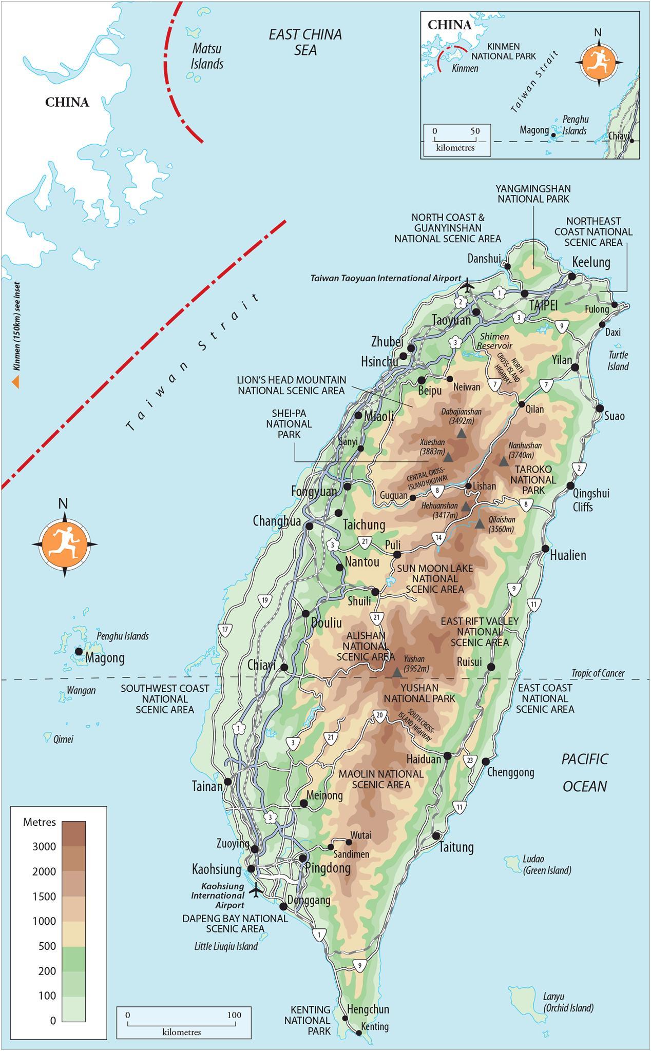
The terrain topography in Taiwan is divided into two parts: the flat to gently rolling plains in the west, where 90% of the population lives, and the mostly rugged forest-covered mountains in the eastern two-thirds. The eastern part of the island is dominated by five mountain ranges, each running from north-northeast to south-southwest, roughly parallel to the east coast of the island as you can see in Taiwan topographic map. As a group, they extend 330 kilometres (210 mi) from north to south and average about 80 kilometres (50 mi) from east to west. They include more than two hundred peaks with elevations of over 3,000 m (9,843 ft).
Taiwan and the country minor islands together have almost 1,700 km of coastline, and the range of landscapes is tremendous as its shown in Taiwan topographic map. Much of the west coast is characterised by lagoons, mudflats and wetlands where migrating birds spend the winter, while the north coast is notably rocky. Starting from the east coast, they are: Taitung Coastal Mountain Range (Hai-an Shan-mo), Central Mountain Range (Chung-yang Shan-mo), Snow Mountain Range (Hsue-shan Shan-mo), Jade Mountain Range (Yu-shan Shan-mo), and Ali Mountain Range (Ali-shan Shan-mo). Taiwan coastline is approximately 1,566 kilometers long. There are four types of coastal landscape based on crust movement, rock formation and the resulting slope and contour of the sea floor as it rises to meet dry land.
Taiwan is a mountainous island. Mountains account for 30% ofits total area, hills and plateaus for 40%, and plains for the remaining 30% as its mentioned in Taiwan topographic map. Taiwan mountainous area consists of mountains of over 1,000 meters, spreading from the east to the central part of the island. Most of the mountain ranges go from north to south. On the outskirts of the mountainous area are hills and plateaus ranging from 100 to 1,000 meters in altitude. Most of the hills are located in the west, especially in Chu-nan and Chia-i. The lowlands are most often found near the sea and rivers. Land formations lower than 100 meters are plains: these include great plains, deltas and valleys. Those surrounded by hills with a flat base in the center are basins, though some basins rise above 100 meters.
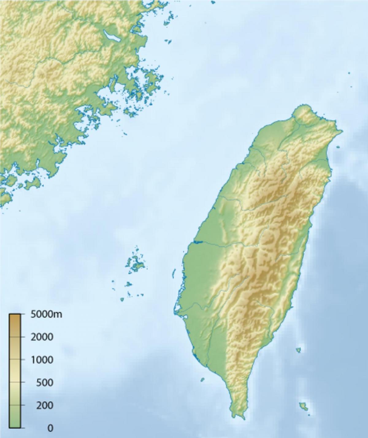
The Taiwan elevation map shows the different altitudes of Taiwan. This altitude map of Taiwan will allow you to know where are the highest and lowest regions of Taiwan in Eastern Asia. The Taiwan elevation map is downloadable in PDF, printable and free.
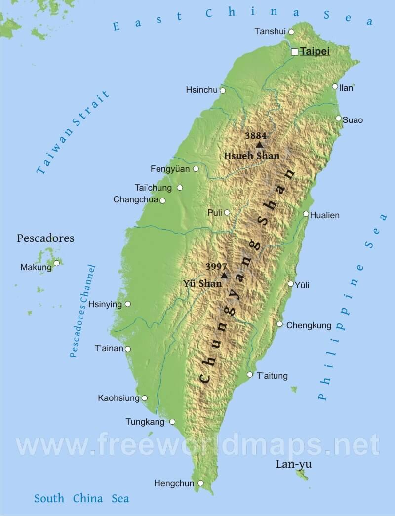
The average elevation range of Taiwan is 1,150 m (3,773 ft). The highest point of Taiwan is Yu Shan, with its official height being 3952 m (12,967 ft) as you can see in Taiwan elevation map. The lowest point of Taiwan is China Sea. The elevation difference between the highest (Yu Shan) and lowest (China Sea) points of Taiwan is 3952 m (2 ft).
Yushan (Chinese: 玉山; pinyin: Yùshān; literally "Jade Mountain"), also Mount Yu is the highest mountain in Taiwan and the fourth highest mountain on an island. In the past, Yushan was known among English-speaking expats and missionaries as Mount Morrison, thought to have been named in honor of the 19th century missionary Robert Morrison. (More about this in the History section.) Today, the mountain is referred to as Yushan or Jade Mountain. The highest elevation point of Yushan range, Yushan, is 3,952 metres (12,966 ft) above sea level as its shown in Taiwan elevation map. Yushan was once in the ocean and raised to the current height because the Eurasian Plate slid under the neighboring Philippine Sea Plate.
Yushan has five main peaks with the Main Peak being the most popular in Taiwan: Yushan Main Peak (玉山主峰), 3,952 m (12,966 ft), Yushan Eastern Peak (玉山東峰), 3,869 m (12,694 ft) – 4.5 kilometres (2.8 mi) from Main Peak, Yushan Northern Peak (玉山北峰), 3,858 m (12,657 elevation ft) – 3.5 kilometres (2.2 mi) from Wind Tunnel (風口), Yushan Southern Peak (玉山南峰), 3,844 m (12,612 ft) – 3.1 kilometres (1.9 mi) from Paiyun Lodge (排雲山莊), Yushan Western Peak (玉山西峰), 3,467 m (11,375 ft) – 4 kilometres (2.5 mi) from Paiyun Lodge (排雲山莊) as its mentioned in Taiwan elevation map.
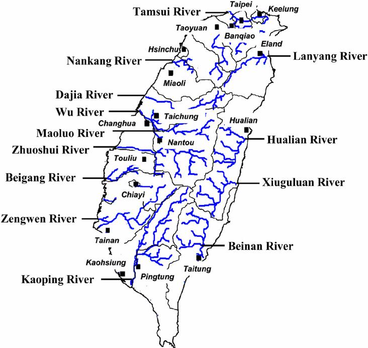
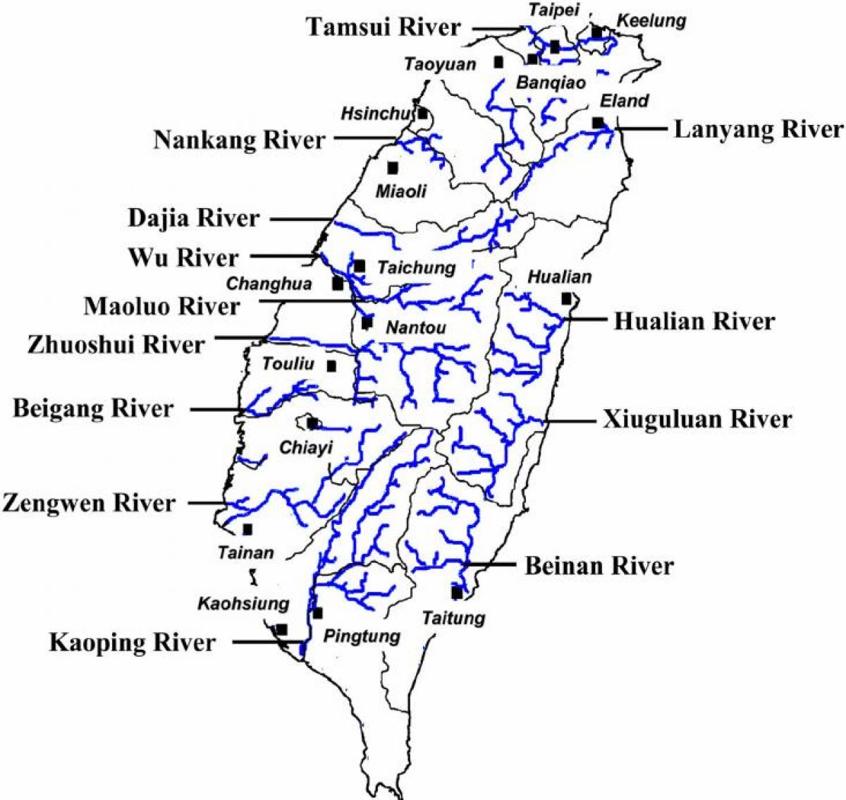
The rivers in Taiwan map shows the principal rivers with their names of Taiwan. The rivers map of Taiwan will allow you to find the main rivers which flow in and through Taiwan in Eastern Asia. The Taiwan rivers map is downloadable in PDF, printable and free.
Taiwan has most of its rivers originating from the mountains with short rapid courses. Rivers in Taiwan are major sources of domestic water, and some are utilized to produce hydroelectric power in the country. Tanshui is the only navigable river, while the longest is Zhuoshui and is heavily tapped for hydropower. Some have served as unofficial boundaries in the country. Zhuoshui River as you can see in Taiwan rivers map, is the longest river in the country covering a distance of 116 miles. The river discharges 28,900 cubic meters per second during peak periods and drains through Changhua, Chiayi, Yunlin SNF Nantou. Zhuoshui River also serves as an unofficial boundary between south and north Taiwan. The watershed of Zhuoshui River covers an area of 3,157 Square kilometers has many dams along its course such as Wushoh, Wujie, and Chichi Weir dams.
Gaoping River is the largest by drainage area in Taiwan, and it is the second biggest river in the country covering a distance of 106 miles as its shown in Taiwan rivers map. The river is also the largest river in Taiwan by volume. The upper regions of Gaoping River flow through Liouguei and Gaoshu through a series of rugged canyons. The river is home to more than 66 fish species out of which 14 are endemic. The river is used for irrigation, a source of water to industries, and as a source of water for domestic consumption. The lower parts of Gaoping River are polluted by industrial discharge as well as from swine farms. Zengwun River drains water to Zengwun Reservoir which is the largest water reservoir in Taiwan. Zengwun River harbors the endangered black-faced spoonbills in the Taijiang National Park. The River has its mouth in the Taiwan Strait.
Tamsui River is the leading in the country by volume and covers a distance of 99 miles. The river originates from Pintien Mountain and has a basin size of 1,053 square miles as its mentioned in Taiwan rivers map. It discharges an average of 210 cubic meters per second. Tamsui River flows from the northern part of Taiwan and begins at the confluence of Xindian Creek and Dahan Creek. Tamsui River flows northwards and northwestwards before emptying into Taiwan Strait. Tamsui River faces massive pollution from illegal industry drainage into the river. Dahan River is one of the largest rivers in Taiwan and originates from the Pintian Mountain. The Dahan River is 84 miles and has a discharge of about 60 meters cubic per second. Like Tamsui River, it is located in the northern part of Taiwan and flows north. It is used for recreational purposes before it turns west to form Shihmen Dam. After Shihmen Dam, Dahan River flows towards the northeast and later joins Tamsui River. The river and the dams along it have provided water for hydroelectricity, for domestic use, irrigation among other purposes.
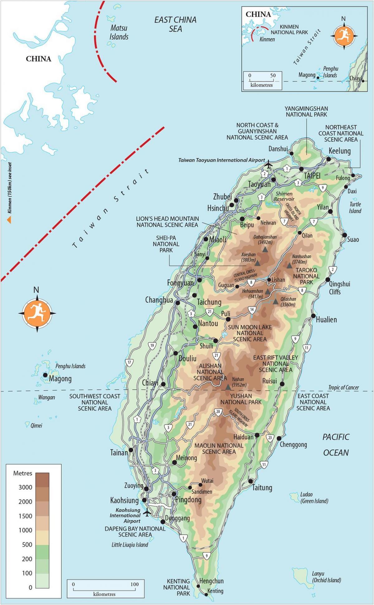
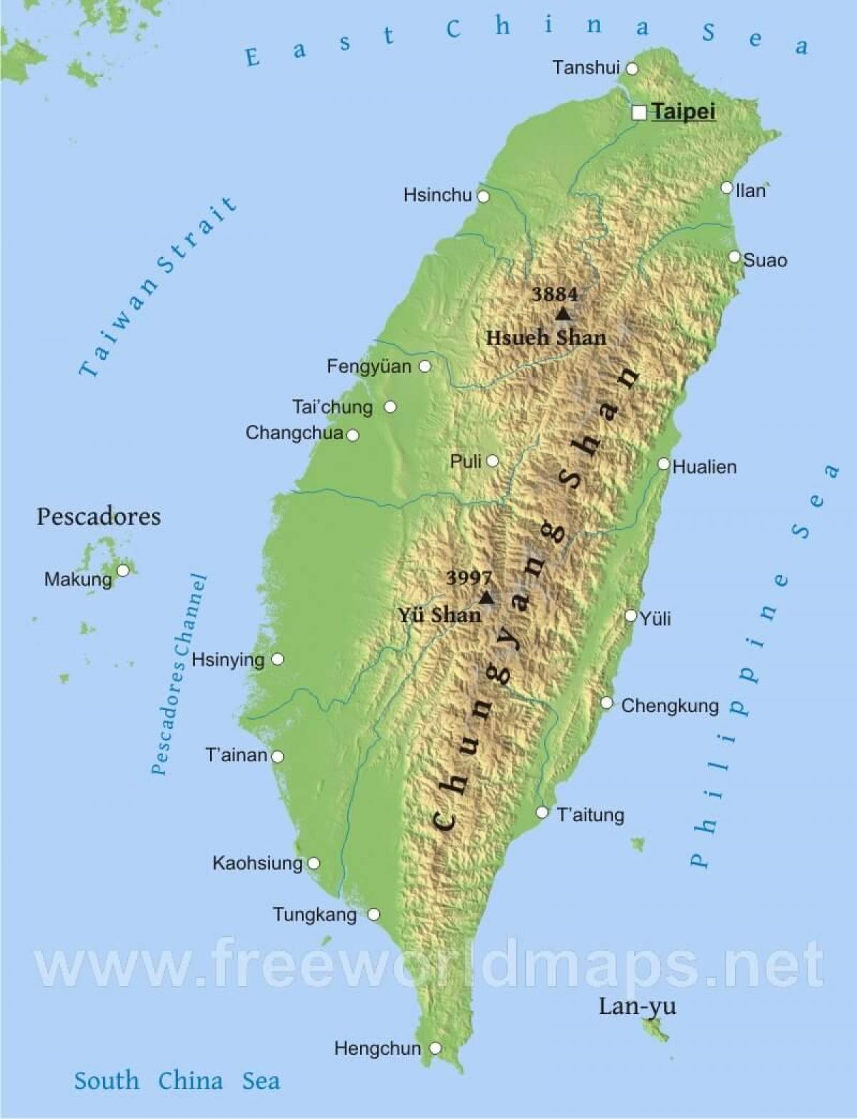
The mountains in Taiwan map shows the principal mountains with their names in Taiwan. The mountains map of Taiwan will allow you to find the main mountains ranges and highest mountains of Taiwan in Eastern Asia. The Taiwan mountains map is downloadable in PDF, printable and free.
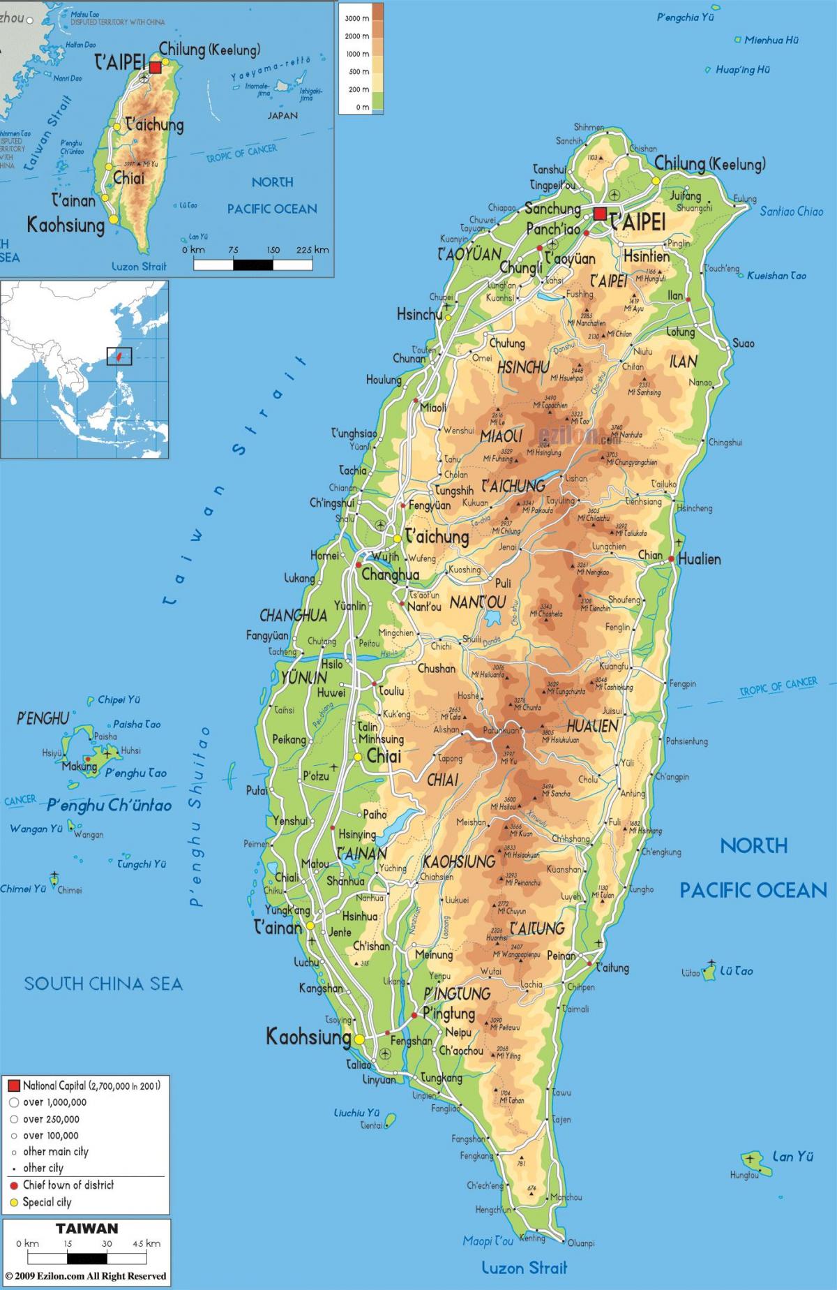
Taiwan is a mountainous and alpine island. The island has the largest number and density of high mountains in the world. There are approximately 165 mountains over 3,000 metres (9,800 ft) above sea level on the island. Mountaineering is one of the most popular activities for many Taiwanese. A list of One Hundred Mountains of Taiwan (台灣百岳列表) was created in 1971, which lists the one hundred mountains over 3,000 m for mountaineering on the island. Climbing all of the one hundred mountains listed is considered the greatest challenge for Taiwanese climbers. Hsuehshan Range (雪山山脈) lies northwest of the Central Mountain Range, beginning at Sandiaojiao in the northeast and gaining elevation as it extends toward the southwest. Syue Mountain, the main peak, is 3,886 m (12,749 ft) high as you can see in Taiwan mountains map.
The Yushan Range (玉山山脈) runs along the southwestern flank of the Central Mountain Range. It includes the island tallest peak, the 3,952 m (12,966 ft) Jade Mountain (Yu Shan) as its shown in Taiwan mountains map. Alishan Range (Chinese: 阿里山山脈) is a mountain range in central-southern region of Taiwan. It is separated by Nantzuhsien River from the Yushan Range, the tallest range of Taiwan on the east of Alishan Range. The highest peak of Alishan Range is Datashan (大塔山), which has a height of 2,663 m (8,737 ft). The Central Mountain Range (中央山脈) extends from Su-ao in the northeast to Eluanbi at the southern tip of the island, forming a ridge of high mountains and serving as the island major watershed for rivers and streams. The mountains are predominantly composed of hard rock formations resistant to weathering and erosion, although heavy rainfall has deeply scarred the sides with gorges and sharp valleys. Taroko National Park, located on the mountainous eastern side of the island, has good examples of mountainous terrain, gorges and erosion caused by a swiftly flowing river.
The East Coast Mountain Range (海岸山脈) extends from the mouth of the Hualien River in the north to Taitung County in the south, and chiefly consist of sandstone and shale as its mentioned in Taiwan mountains map. Although Hsinkangshan (新港山), the highest peak, reaches an elevation of 1,682 m (5,518 ft), most of the range is composed of large hills. Small streams have developed on the flanks, but only one large river cuts across the range. Badlands are located at the western foot of the range, where the ground water level is the lowest and rock formations are the least resistant to weathering. Raised coral reefs along the east coast and the frequent occurrences of earthquakes in the rift valley indicate that the fault block is still rising.

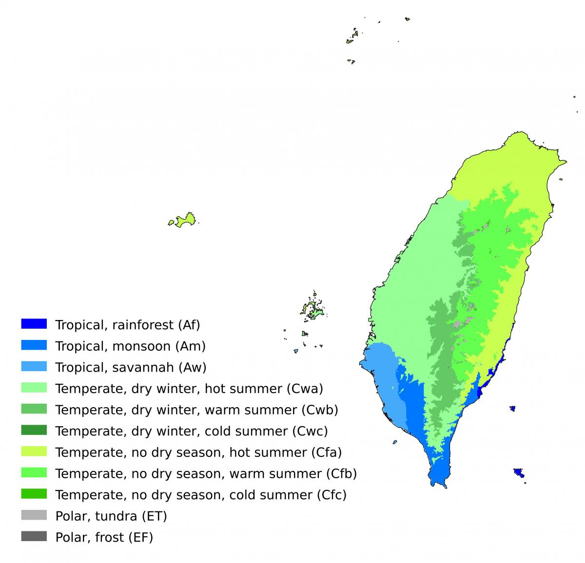
The Taiwan climate map shows average temperature and climate zones of Taiwan. This climate map of Taiwan will allow you to know weather, average precipitation, average sunshine and different climates of Taiwan in Eastern Asia. The Taiwan climate map is downloadable in PDF, printable and free.
In Taiwan, formerly Formosa, an island in East Asia crossed by the Tropic of Cancer, the climate is tropical, with mild winters and hot, rainy summers. The period May-September is very rainy throughout the country because of the summer monsoon, while in the other seasons, rainfall depends on latitude and slope exposure. However, winter is the least rainy season everywhere. Summer is hot, humid and rainy, with more frequent rains (unlike in winter) along the southern coast. The temperatures are quite uniform from north to south: in July and August, the daily average at sea level is around is 28.5 °C (83 °F) along the coasts and 30.5 °C (87 °F) in Taipei as you can see in Taiwan climate map. The north-west coast, from Taichung to Taoyuan, experiences a relative decrease in rainfall in July. Since the tropical rains are usually intense but short-lived, the amount of sunshine in summer is acceptable, however, in this season, sticky and unpleasant heat dominates.
In winter, the temperature in Taiwan is pleasant in the south, where highs in January are about 23 °C (73 °F), and the sun often shines, while in the north (see Taipei), the climate is cooler and cloudier, with average maximum temperatures about 19 °C (66 °F) as its shown in Taiwan climate map. Owing to maritime influence and low latitude, night-time temperatures are rarely cold and never drop below freezing (0 °C or 32 °F). However, sometimes, there can be very cool days in the north, with highs about 10/12 °C (50/54 °F). In spring, in April and early May, early thunderstorms begin to occur in the afternoon, starting from the north and the interior. The monsoon arrives on the island around May 10 - May 20, coming from the south. It brings heavy rainfall throughout the island, but especially along the southwest coast, from Tainan to Hengchun, in addition to the highlands of the interior.
The interior of Taiwan island is very green and is occupied by mountains. In the Yangmingshan National Park, north of Taipei, it can snow above 1,000 meters (3,300 feet) during cold spells as its shown in Taiwan climate map. The highest peak is Mount Qixing, 1,120 meters (3,670 feet) high. The highest peak in Taiwan is Yushan (formerly Mount Morrison), located in the central part of the island and 3,952 meters (12,966 feet) high, whose name, "Jade Mountain", derives from the contrast created in winter between the snow-capped peak and the sky in the background. Above 2,000 meters (6,500 feet), winter is quite cold, and there is some chance of snow and frosts, while summer is cool but very rainy. On the top of Yushan, the average temperature in the winter months is around freezing (and sometimes the temperature can drop as low as -10 °C or 14 °F), while in summer, it is around 9 °C (48 °F).