

You can find on this page the Taiwan road map to print and to download in PDF. The Taiwan driving map presents the detailed road network, main highways and free motorways of Taiwan in Eastern Asia.

The Taiwan road map shows all roads network and main roads of Taiwan. This road map of Taiwan will allow you to preparing your routes and find your routes through the roads of Taiwan in Eastern Asia. The Taiwan roads map is downloadable in PDF, printable and free.
Because of the geographical limitations, over 90% of roads are located in the western area of the island. From 1991 to 2006, the average growth rate of the total length of roads was about 2.17% per year while that of registered vehicles was about 4.4% per year. Most Taiwanese road signs have internationally recognisable symbols. However, street and place names are generally only given in Chinese. Roads have a numbering system: Roads running north-south usually have odd numbers, Roads running east-west usually have even numbers. There are four types of roads in Taiwan as you can see in Taiwan roads map: Township routes, National highways: numbered 1-10, Provincial highways: numbered 1-28 and 61-88, County routes: numbered 101-205. Taiwan freeways are tolled. It is possible to pay in cash, while pre-paid tickets can be bought at local convenience stores.
Provincial Highway 9 is the longest road construction project in Taiwan. The 476km road extends from Taipei, through to New Taipei City, to Yilan, Hualien, Taitung, and finally ending in Pingtung as its shown in Taiwan roads map. Starting from the Executive Yuan in downtown Taipei, the road heads east to the mountains. The infamous Taipei-Yilan portion of the highway offers unsurpassed high-cliff coastal beauty, but much care should be taken while navigating its “nine curves and eighteen twists”. However, at the final section of the road, you can enjoy a commanding view of the Lan-Yang Plain. It is an entirely different world starting from Yilan. The road here is wide, with much less traffic than Taipei, and your drive will be accompanied on both sides by perfectly symmetrical rice fields. After passing through several tunnels, we you will have arrived at the beautiful fishing port, Suao.
Taiwan road system includes as its mentioned in Taiwan roads map: (1) intercity highway system, which is 21,224 kilometers in length, and (2) a city roadway system, which is 18,062 kilometers in length and distributed over the entire island. Because of the geographical limitations, over 90% of roads are located in western Taiwan3. The total length of the road system increased from 28,473 kilometers in 1991 to 39,286 kilometers in 2006, and the annual growth rate was 2.17%. During the same period, the density of road system increased from 827 meters per square kilometer to 1,091 meters per square kilometer. Compared with the growth rate of road length (2.17% per year), the growth rate of vehicles (4.4% per year) has been higher in the past 15 years.
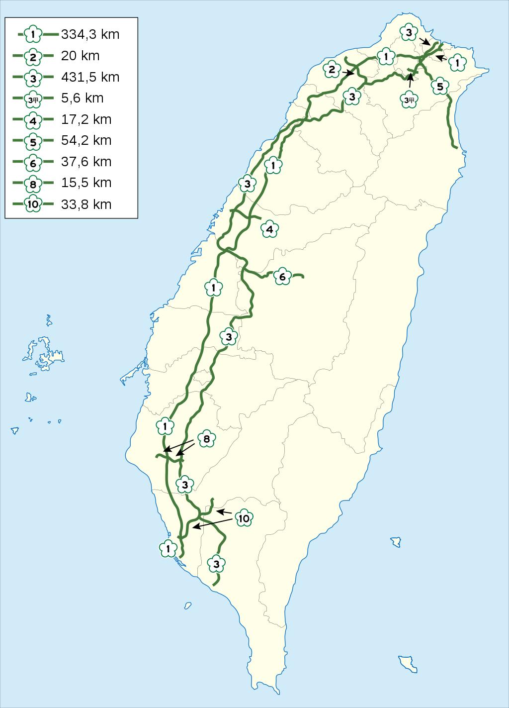
The Taiwan highway map shows toll and free motorways of Taiwan. This highways map of Taiwan will allow you to prepare your routes on motorways of Taiwan in Eastern Asia. The Taiwan highway map is downloadable in PDF, printable and free.
Highways in Taiwan are classified into four types: National highways: 1–10 (labeled as Freeway), Provincial highways: 1–39, 61–88 (the latter are labeled as Expressway), County routes: 101–205, Township routes as you can see in Taiwan highway map. The system does not apply to other parts of the Republic of China (ROC), namely Kinmen and Lienchiang counties, and islands in the South China Sea. As a general rule, the odd numbers represent north-south highways and even numbers represent east-west. The numbers increase moving west to east and north to south. Major north-south provincial highways are indicated by a one-digit number. Special routes of a highway use the same number, followed by a heavenly stem character. However, for English translation, these characters are replaced by letters in the alphabetical order.
The first controlled-access highway, and a predecessor to the national highways in Taiwan, was the MacArthur Thruway, built in 1964 between Keelung and Taipei as its shown in Taiwan highway map. Construction on the first modern national highway, National Highway 1 began in 1971. The northern section between Keelung and Zhongli was completed in 1974, and the entire freeway was completed in 1978. It runs from the northern harbor city of Keelung to the southern harbor city of Kaohsiung, while there was an 8.6-kilometre (5.3 mi) branch (No. 1A) connecting to Chiang Kai-shek International Airport (now Taiwan Taoyuan International Airport). Construction began on the other freeways in the late 1980s. The northern section of the second north-south freeway (National Highway 3) between Xizhi and Hsinchu was completed in 1997. The No. 1A Branch was extended to link No. 3 Freeway at Yingge, Taipei, and renamed as the National Highway 2.
Provincial highways (of Taiwan Province) are administered by Directorate General of Highways under Department of Transportation and Communications since 1999 as its mentioned in Taiwan highway map. Before the mid-1990s, the route numbers of provincial highways were limited to 1–27. In the 1992, planning started for 12 east-west expressways and the West Coast Expressway, indicated by route numbers greater than 60, to ease the congestion in the freeways. County routes are numbered from 101 to 205 since the numbered highways in Penghu (Pescadores) are incorporated into the system. The lowest number 101 is in Taipei. The route numbers generally increase moving north to south. Routes 201 to 205 are in Penghu. A township route is prefixed the abbreviation of the county in a Chinese character where it is located. The sample signs above show Hsinchu Routes 22, 21, and 23.